

A Chinese company’s publication of AI-enhanced satellite images of US bases in the Middle East is helping Iranian forces identify targets, US intelligence believes.
The ABC has been briefed on the intelligence by a source inside US defence, who says the images are endangering lives.
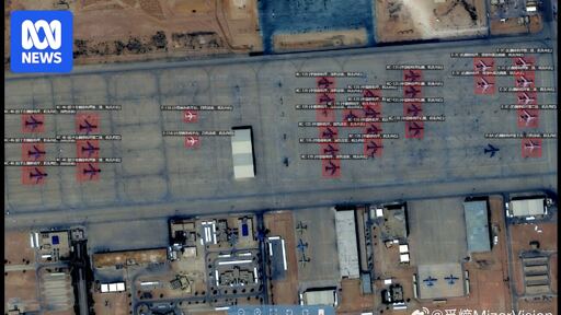
Chinese geospatial artificial intelligence and software company MizarVision, which the Chinese government has a small ownership stake in, has been publishing detailed satellite images with tagging data of multiple US military sites in the lead-up to, and during, the Iran war.
The imagery showcases an AI tool that identifies and tags military forces across vast areas, a capability that once required the resources of a national intelligence agency.
And? Who gives a fuck. I would expect China and Russia to help Iran. Why wouldn’t they?
Lemmy get this straight. The Trump admin was fine with satellite data being shared for all these years and then they commit a warcrime where the data is used to verify it indeed was a warcrime and now they want satellite data banned.
HMMMMMMMMMM
US is learning the hard way what “soft power” means, and what it means to lose it.
Glory to Iran. May they be successful in their mission to push back the pedophile invaders.
“Endangering lives”? Iran striking US bases will almost certainly lead to fewer lives lost.
HumanAmerican lifes.
common China W